Utila: West End
Saturday, June 26, 2004
016-4.440 N086-58.440 W
Ahoy from the West End of Utila!
 This is a far cry from the
West End of Roatan. Other than a couple of populated cays about a mile away
there's nothing around here. Just a few fishermen and a few dive boats in the
morning. We had gotten tired of getting rolled by the ferries, ash from trash
being burned ashore, loud music playing late into the night, mediocre food, and
not being able to dive off of the dinghy due to high winds. As a result we
decided to head down to the W end of Utila.
This is a far cry from the
West End of Roatan. Other than a couple of populated cays about a mile away
there's nothing around here. Just a few fishermen and a few dive boats in the
morning. We had gotten tired of getting rolled by the ferries, ash from trash
being burned ashore, loud music playing late into the night, mediocre food, and
not being able to dive off of the dinghy due to high winds. As a result we
decided to head down to the W end of Utila.
The Calder guide makes it sound like there there are very few overnight anchorages in the area. I think that he missed a few things. We anchored by the point at the west end (16-04.73N 86-59.26) in a nice 10' deep grass patch. The holding was fine as we rode out a squall with 48 Kt winds and we didn't move. This site provided great access to the dive balls on the NW end of the island. The only problem was that the winds seem to wrap around the end of the island and turned our E winds into SE winds, which gave them almost a 2 mile fetch in which to build up. With 20-25 kt winds we had 1-2' seas, which prompted us to seek better protection.
There's a 50' deep channel that runs about 100 yards off of the beach all along the western end of Utila. It's easy to follow the ark blue channel in just about any reasonable light. We moved about 1 mile to the ESE to an anchorage (16-04.514N 86-58.442W) which provides great protection from the E and N. We anchored in 15' of dense turtle grass and the CQR completely buried itself. We had nice calm seas despite the winds blowing 25+ out of the E. This is a very pretty anchorage with a manicured white sand beach, a dock and three well maintained vacation houses. It's about a mile to the cays and dive balls on the S side and it's about the same distance to the balls on the N side.
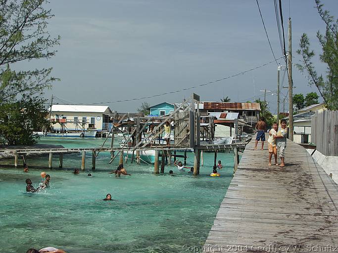 We visited the
populated cays known as Jewel (aka Upper aka Suck-Suck) and Pigeon (aka Lower)
and found that they were highly reminiscent of the Settlement at Guanaja,
Honduras. These cays are probably 1/4 of a mile across and and located next to
one another. A wooden bridge connects the two. To describe them as populated
understates the density. Every square inch is covered by housing and two person
wide sidewalks run between the ramshackle buildings. Fishing appears to be the
primary industry (which probably explains the lack of fish on the reef) and the
island is ringed by fishing boats. I suspect that there's a worm that eats wood
down here as all of the boats are lifted out of the water via hoists and the
pilings that support just about everything are nibbled away where they meet the
water. We had an enjoyable lunch at Susan's, which is just before the bridge on
Jewel cay.
We visited the
populated cays known as Jewel (aka Upper aka Suck-Suck) and Pigeon (aka Lower)
and found that they were highly reminiscent of the Settlement at Guanaja,
Honduras. These cays are probably 1/4 of a mile across and and located next to
one another. A wooden bridge connects the two. To describe them as populated
understates the density. Every square inch is covered by housing and two person
wide sidewalks run between the ramshackle buildings. Fishing appears to be the
primary industry (which probably explains the lack of fish on the reef) and the
island is ringed by fishing boats. I suspect that there's a worm that eats wood
down here as all of the boats are lifted out of the water via hoists and the
pilings that support just about everything are nibbled away where they meet the
water. We had an enjoyable lunch at Susan's, which is just before the bridge on
Jewel cay.
The weather products out of the National Weather Service have been extremely unreliable lately. The positions of tropical waves, which come about every 3 days, don't match between forecasters and it's becoming extremely difficult to plan when we're going to move. We had expected to move tomorrow, but now it looks like we're headed westward to Punta Sal today. Gotta get the boat ready!
-- Geoff & Sue
Log ID: 514
Photos/Video:
To receive these logs via e-mail, please subscribe to the mailing list or you can follow us on FaceBook by clicking: